Thursday 11 December 2014

Pioneers of Fiordland


Milford Sound has had scenic appeal for tourists since colonial times. Photo / Paul Rush
A gentle stroll along Te Anau's lakeside path soon tells me I'm in the very heart of Fiordland National Park.
Beside the Visitor Centre I meet Quintin McKinnon, the bold Scottish surveyor who discovered the first overland route to Milford Sound, now known as the Milford Track. The bronze statue of this short, stocky pioneer presents him as a confident man with a faraway look in his eye.
I meet local identity Ray Willets, a current Milford Track guide at a sprightly 76 years of age.
"I grew a beard and played Quintin McKinnon for 12 months, to raise funds for the statue that was built in 1988, to mark the 100th anniversary of the first crossing of McKinnon Pass," Ray tells me.
"Before the Milford Track route was opened Te Anau slumbered on the edge of the unknown. It was McKinnon's exploits that gave birth to our community."
This brief encounter with Te Anau's colourful past inspires me to join Richard Parkinson on his Heritage Trails mini-van tour of the town.
From a prominent lookout point, we gaze across the lake to Garden Point where McKinnon lived in the bush for a number of years.
"He lived in isolation to cure his intemperance and guided parties on the Milford Track," says Parkinson.
"In 1892 he disappeared on a solo trip to Milford. His boat was found submerged at the Dot Islands, but the non-swimmer's body was never discovered."
Te Anau sits serenely on the eastern side of the South Island's largest lake, straggling along the shoreline in one of the country's most scenic locations.
The first resident was Richard Henry, who built himself a slab cottage on the south shore of the lake, opposite the present motor camp, in 1883.
Within a few years he became disillusioned by the increasing crowd of tourists coming through. This was providential indeed, as in 1894 he was appointed curator of the world's first island sanctuary for birds.
For 15 hard years he worked in Dusky Sound, trapping endangered kakapo and kiwi and transferring over 700 to Resolution Island.
During this period misguided politicians approved the introduction of mustelids for rabbit control. Henry realised that the stoats and weasels were swimming to the island and undoing his efforts. After years of perseverance, he had to admit defeat but he is still revered as the grandfather of New Zealand's wildlife conservation movement.
Our heritage tour brings us to Te Anau Downs harbour where boats leave daily for the Milford Track.
Parkinson recounts the exploits of James McKerrow, who conducted a waterborne survey of the lake in 1864. Welsh sealing captain, John Grono, helped McKinnon cut the Milford Track and William Homer discovered the saddle above the tunnel on the Milford Road.
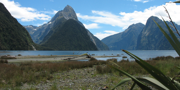
I travel by bus to Milford Sound and gaze in wonder at the grand scene of sheer rock walls plummeting into the black depths of the fiord. Mitre Peak's cleft summit rears up sharply from the black depths, mirrored to perfection in the glassy waters.
According to Maori legend, the great sea-god, Tu-te-Raki-Whanoa, carved Fiordland out of a solid mountain block with his great adze. Milford Sound has long been recognised as his greatest work.
The Waitaha and early Maori tribes followed the Greenstone and Hollyford Valleys to the West Coast in search of pounamu or greenstone.
Milford's first settler, Donald Sutherland, arrived with his faithful dog, John O'Groat, in 1877 and erected thatched huts by the freshwater basin he called the "City of Milford". He had set out from Dunedin in 1877 in an open sail boat, passing through Foveaux Strait and making the perilous passage up the Fiordland coast. Milford Sound was to become his home for the next 40 years.
He went on to construct a 12-room hotel to serve the growing influx of steamer passengers on sightseeing cruises.
Sutherland possessed a whimsical sense of humour and referred to his visitors as "asphalters" (city dwellers) and "shadow-catchers" (photographers). During the winters he lived a hermit-like existence.
With fellow adventurer, John McKay, he explored the Arthur River in 1880, having spotted a distant flash of water over the treetops. They came upon a waterfall and tossed a coin for the naming rights, which were won by McKay.
Later, they arrived at the base of a giant cascade, which became the Sutherland Falls - the third-highest in the world.
On a recent three-day tramp down the Hollyford Valley to Martins Bay, my guide recalled the exploits of Davey Gunn, who he earnestly described as "the greatest man who ever lived".
Often referred to as New Zealand's own Davey Crockett and the first real Southern Man, Gunn was as tight-lipped and laconic as any Speight's-drinking actor on today's flat screen.
In 1926, the legendary Gunn took over the Hollyford cattle run from the sons of Daniel McKenzie, the pioneer of Martins Bay. When the spread of red deer ruined his pastures he diversified into tourism, taking horse treks to remote wilderness camps.
One evening he heard a Fox Moth aircraft crash into the surf on Big Bay beach. Running into the sea he found one person dead and four injured. Realising they needed urgent medical attention he rode his horse, rowed a dinghy and ran on foot on an incredible mercy dash that covered 90 kilometres in 20 hours.
Fiordland has a panoply of pioneering heroes. The first European explorers, surveyors, run holders and traders all contributed to the beginnings of Te Anau.
Today, when I look at the modern Southern Man who receives an accolade from his cobber for producing a pack of Speight's beer on a muster, I think of the true pioneers that have gone before and feel humbled by their achievements.
It takes a visit to Te Anau and a wilderness tramp in the heart of Fiordland to understand the sacrifices they made and the hardships they endured.

Thanks to NZ Herald to run this article written by Paul Rush.

Thursday 5 June 2014

A Romance of Lake Wakatipu


Note 15.—Clutha River.


From Victoria University website:  http://nzetc.victoria.ac.nz/tm/scholarly/tei-CarARom-t1-back-d1-d15.html#name-007584-mention


Mr. James McKerrow, formerly District Surveyor of Otago, whose early explorations and, considering the state of the country in these days, astonishingly-correct observations did far more towards settling the country and developing its resources than those of any other man, makes the following pertinent remarks regarding the economics of these inland water systems: "The lakes are a very great feature in the natural history of the country, and perform a most important function in its economy. They act as regulating reservoirs to the mountain-torrents emerging from them, for over their broad surface the floods find room to spread their volume until there be time given for the accumulation to pass away in the steady flow of one river. The value of the lakes as a means of restraining such rivers as the Clutha within safe limits will more readily appear when it is considered that the Wakatipu alone covers 114 square miles, the Wanaka 75 square miles, and the Hawea 48 square miles—altogether 237 square miles of lake to regulate its volume. These lakes have also a rise and fall of several feet. From the data thus given it will be evident that but for the tempering influences of the lakes, the Clutha, in place of flowing along a well-defined channel, a perennial stream, would devastate the whole country."
After nearly thirty years' European experience, the soundness of this theory, put forward at a time when the interior was terra incognita, can be fully attested. With the exception of a few miles of low-lying country at its mouth the Clutha has never been known to overflow its banks. With a body of water like this well confined, the bed in some instances has been scooped out to a great depth, the banks alone in these cases giving a drop of from 50ft. to 60ft. The country through which it flows is widely diversified in its aspects, varying from alluvial flats of great extent to abrupt mountain-gorges, in which barely sufficient room exists for road-making. Through some of its rocky defiles the river runs with great velocity. The average current, however, does not exceed four knots. In appearance these defiles are, as a rule, wildly grand. They form so many necks or funnels in the body of the river, at which the channel gets so contracted that the current receives all the greater impetus. The rush is for the most part that of a smooth volume, without any sign of submerged rocks or boulders. It does not demand great powers of imagination to invest these defiles with a handful of satanic lore and describe them as the devil's mill-streams, although it must be confessed the hydraulics are not generally recognised branches in demonology. The scene overhead is equally wild and suggestive. The precipices are high, the gorges in that way getting completely walled in. These precipices exhibit rocks and boulders striking all manner of threatening attitudes, from the slight list forward to the distinctly dangerous-looking, overhanging ledge. Some of these mighty excrescences look like turrets, embattlements, and hill-forts, but they are all too great, too magnificent, to be associated with the warlike operations of man. If we are to do them substantial justice we must bring the imaginative powers again into requisition and people them with a race of giants, armed to the teeth with the artilleries of heaven. That is the only way oat of the difficulty, and even then we may congratulate ourselves upon having escaped lightly.

Tuesday 11 September 2012

Sunday 8 January 2012

James McKerrow, the explorer and namer.

                                                                                                          
During my 3 week holiday I spent time travelling through country that my Great Grand Father explored between 1861-63 at the head of Lae Wanaka and Wakatipu.
Above we see the Routeburn, Caples, Rock Brun, Beans Burn, the Rees and the Dart valleys he explored, surveyed and named. Photo: Bob McKerrow.
The west and east peaks of Mt. Earnslaw. Photo: Bob McKerrow. Photo: Bob McKerrow

James McKerrow was a prolific namer of features he surveyed. Over the years I have tried to climb, walk, raft or kayak, or just look and photograph the places he named..The map below conveys the extent of his work over one of the remotest parts of New Zealand


Since much of the country over which he passed was virgin, McKerrow took on himself the task of naming prominent features of the landscape. The policy employed in this work he described thus:

“ In naming of objects, those already in use in the district were always adopted, they are generally defined to a few creeks or perhaps a hill or two in the vicinity of the respective stations. The other names I either endeavoured to make descriptive or suggestive: this, in the case of the more prominent peaks, appears to me to be of much consequence to the traveller, for they become so many finger posts pointing the way. The great landmarks, Leaning Rock, Double Cone, and Black Peak, I found of much service in determining my whereabouts at the beginning of the survey; their names are legible in characters not to be mistaken”(1).

“ A great number of descriptive names were given thus: Cathedral Peaks, The Monument, the Beehive, the Crown, the Coronet, Tooth Peaks, Twin Peaks, the Minarets, Mt. Sentinel, Titan Rocks, Spire Peak, and so on and so on……

The mountain ranges were named after distinguished men in science, literature, travel and position, such as Kepler, Humbolt, Murchison,. Livingstone,, Forbes ( Professor of Natural Philosophy 60 years ago at Edinburgh, an authority on glaciers), Hunter (John, Anatomist) Sturt (Australian Explorer), Albert ( late Prince Consort)) Eglinton (Lord Lieutentant of Ireland and Lord Rector Glasgow University), Richardson (Sir John),Thomson, Hector, Garvie, Buchanan (local and well known), Goldie Hill and Bryce Burn were after my two men who were true and faithful throughout.” (2)

“ An island in Lake Manawa-pori is Poman, named in 1862 by James McKerrow, after the principal Island or “mainland” of Orkney Islands in Scotland.,” with a view to help the rhythm of the future poets, who will describe in flowing numbers the charms of beautiful Manapouri, as McKerrow prophesises…….

The Freeman was named by Mr. McKerrow in honour of Mr. Freeman Jackson, a very early runholder (3)….When Mr. James McKerrow was engaged with reconnoitring surveys during the years 1861-63, he named a number of places.” A few of these he named in the Wakatipu and Te Anau districts as follows: He gave the name Caples to one of the branches of the Greenstone, rivers….McKerrow named the Lingstone Mountains after Mr. D. Livingstine, the celebrated African explorer. David Peak(6802 ft/)in memory of Dr. Livingston’s christian name, Moffat Peak (5848 ft) , an African missionary and father-in-law of Livingstone. Eglinton River and Mountain after the Earl of Eglinton and Winton at that time Lord Lieutenanr of Ireland. Skelmorlie Peak (5933 ft.) and Larg Peak (5555 ft.)are both Ayrshire names. Mount Christina (8675 ft.) after a girl who was companion to Mrs. McKerrow in his absence. Clinto River, Te Anau, after one of the family names of the Duke of Newcastle, who was Colonial Secretary in 1863. Worsely Creek, North Fiord, Te Anau, named after the sheep farmer who drayed the boar for the surveyors from Manapouri Lake to Re Anau. Nurse Creek, after another sheep farmer, Lakes McKellar and Gunn after David McKellar and George Gunn….. Lake Fergus was named after Hon. T. Fergus in 1863. Bob’s cove was named after Bob Fortune, Mr. Rees’s boatman” (4)

“ In the Doon, Dean Hill, Bean Forrest, Afton and other Scottish names Mr. McKerrow honoured the land of his birth,(5) Mt. Pisgah was taken from the bible. It was the vantage point from which the promised land was seen.(6).

In his book, Otago Placenames (7), Mr. H. Beattie gives an exhaustive list of Mcerrow’s placenames. “ Besides J.T. Thomson, the most popular name giver in our history was probably James McKerrow”, he states. Mr. Beattie goes on to list more than 220 place names which are associated with McKerrow’s labours.

(1) Otago Prov. Gaz. Vol. V, July 23,1862. P 16.

(2) Letter to Hocken.

(3) Roberts, W.H.S. Place Names and Early of Otago and Southland, P.32.

" " Maori nomenclature, Early History of Otago. P.47

(4) Roberts. P.48. Roberts does not make it absolutely clear whether or not McKerrow gives the last two names.

(5) Kilmarnock Standard, 22nd August, 1903/

(6) McKerrow’s Reminiscences.

(7) Beattie, H. Otago Place Names, Pp. 78-86.
By 1861 there were several newly established sheep stations on the south end of the lake, when James McKerrow first arrived to carry out survey work. In 1862 McKerrow surveyed the lake in a whaleboat.


Saturday 4 June 2011

Reflections on the work of James McKerrow', explorer & surveyor

Left: James McKerrow, Explorer, surveyor and Surveyor General of New Zealand.


Later historians have been generous in their estimates of McKerrow’s work. Mr. R. O. Carrick for example describes him as “Mr. James McKerrow, one of the earliest and most enterprising of our Southern explorers . . . whose early explorations and considering the state of the country in those days astonishingly correct observations did far more towards settling the country and developing its resources than those of any other man”.

The Royal Astronomical Society’s tribute, paid on McKerrow’s death in 1919, indicates that his worth was
recognized by leading scientific bodies. “Years of arduous work . . . in the early days demonstrate to the full the loyalty, grit, and solid determination that he possessed and displayed in the carrying out of expert and scientific work at a time when means of communications were of the most primitive description, and when the surveying of the mountainous forest lands in the south necessitated the finest qualities that man can possess.

But, intent on doing his duty, he carried out his responsible work unappalled by dangers which rarely cross the path of a professional man”.

McKerrow’s intimate knowledge of the interior was fully utilized by those requiring information on the region. “Select Committee for Roads and their Construction” appointed by the Otago Provincial Council asked him his opinion about the possibility of running a road through to Queenstown via the Kawarau Gorge. McKerrow pointed out the inherent difficulties of making such a road, and the immense expenditure of time
and money required. In response to a series of questions he also gave his opinion on the most profitable and speedy way of getting supplies through immediately to the Wakatipu goldfield, and the measures he considered necessary to compete with Invercargill for the trade.

In a more specialized field, that of geology, McKerrow’s observations were of particular significance. In a paper read before the Otage Institute on July 19, 1870, and later printed in the Transactions of the New Zealand Institute, he discussed the “Physical Geography of the Lake Districts of Otago.

After referring briefly to the areas, dimensions, altitudes and positions of the lakes, he pointed out that they were long and thin, lay lengthwise in their valleys had precipitous sides, surfaces not differing greatly in altitude, and terminated at the point where the valleys broadened out into plains. On each side and at the
southern ends there invariably lay vast areas of shingle and large blocks of rock. It appeared that some great natural cause had had a uniform action in producing these lakes. McKerrow contended that the glaciers lying on the side of the mountains were puny descendants of glaciers which had formerly filled valley and lake bed, and had slid slowly but irresistibly forward, carrying with them the spoil of the mountain, gradually working
a bed deeper and deeper, and finally depositing their spoil as lateral and terminal moraines. Soundings taken of the depth of Lake Wakatipu supported certain corollaries of this theory, and McKerrow drew further support for his contentions by explaining why New Zealand was at one time cold enough to contain such large glaciers. The present condition of lake and river, he maintained, must however have been in existence for a long time if the conclusions he drew from the slow silting up at the heads of the lakes were valid. He pointed out that the rivers were gradually eroding their courses to a lower level, with the result that several small lakes had been transformed into valleys.

Rivers then ran through them and dashed over the moraine as rapids. From these observations and taking into consideration the great disintegrating power of frost, it could be readily understood to what an extent the mountains were denuded every year. “Speaking on the Lake Districts in a general manner”, he concluded “It may be observed that, considering the extent of agricultural, pastoral and forest land that abounds in them, their mineral products, their delightful climate, and extent of inland navigation, they have within their own borders all the man elements that render communities prosperous and ourishing.”

McKerrow’s paper was of great interest to geologists throughout New Zealand since by attributing the formation of Wakatipu to glacial erosion he rejected the theory of di erential subsidence propounded in 1869 by no less an authority than Sir James Hector

In 1876, F.W. Hutton, in a paper read before theWellington Philosophical Society said, “I need scarcely say that I agree with Mr. McKerrow . . . In his paper McKerrow points out, I believe for the first time, the very important fact that the constrained exure of a solid body like ice, when passing from one angle of inclination to another, would greatly increase the friction at this particular point”.

McKerrow’s theory in later years received support from such men as Sir Archibald Geikie, Professor Hein, Professor Penck and Tyndall the Physicist .

More recently the view has been than these two theories both contain elements of truth.

                       James McKerrow in his final years

It says much for McKerrow’s keen and analytical powers of observation and for his wide scientific knowledge that he, an amateur geologist, was able to contest points of geological theory with the geological authorities of the day. Such was the high regard in which McKerrow was held in geographical and geological circles that Sir Roderick Impey Murchison, the President of the Royal Geographical Society and a geologist
of world wide reputation, saw fit to link the young surveyor’s name with those of Hector and Haast. These three men had all had papers read in 1864 before the Society, McKerrow’s being his report to Mr. Thomson on the lake district previously published in the Otago Provincial Gazette. In his address to  the society at an anniversary meeting on the 23 May, 1864, the President said: “Three papers of great interest have been communicated to the Society, which throw additional light upon the physical geography of the hitherto unsur veyed districts of the great middle island of New Zealand, and certain new facts illustrative of glacial action. I consider it, indeed, to be a fortunate circumstance for our science, that these regions should
have been visited by such men as Dr. Hector, McKerrow and Dr. Haast”. McKerrow’s subsequent election as an F.R.G.S. can perhaps be attributed to Sir Roderick’s remarks.

Practically and scientifically McKerrow’s journeys were of value to his fellow men, but they also a ected him personally in such a way that for the rest of his life he had a nostalgia for the wide open spaces, the lakes and the bush-clad hills.

Professor James Park, an explorer of a later day describes some of the difficulties of such journeys, and then goes on “But the gains were great. The man has not yet been born who will ever forget the blazing campfire and itting shadows that chase one another from tree to tree, the blue sky overhead, the vitalizingwhiff of the mountain air, the scents of the forest, the murmur of the nearby stream, the boom of the bittern, the shrill cry
of the kakapo r the clear call of the kiwi. When to these we ad the quest of adventure and the joy of discovery we have a ombination of in uence that make a powerful appeal to the pimitive instincts of man”.

“For the time being the party forms a little self-governing, elf-contained community. For the common weal every man ust exercise patience and self-restraint, and in none are these qualities more required than in the leader. It is his duty to allot each man his particular task, to call the time of starting and of camping. The daily round, the close association, and perhaps more than all, the community of ideals which brings together
kindred souls for a common and tends to foster a spirit of comradeship that often ripens into lifelong friendship.”

James McKerrow was an ideal leader for such a small self- contained community. Daring without being foolhardy, never expecting more of his companions than of himself, quick to take a lead in apparently trivial matters such as changing wet clothes promptly or drinking sparingly of cold water on a hot  day, he contributed an impressive quality of leadership towards the success of the expedition. One incident typifies McKerrow the man. On one part of a return journey something went wrong with the compass, and McKerrow was forced to take bearings from the stars. Goldie was not satisfied with the results, and declared they were heading in the wrong direction.

He refused to proceed further, and after signing a paper to the effect that he was taking such a course of his own free will, he struck out by himself. Three days later he returned and to his astonishment found McKerrow still at the same place.

Goldie expressed his surprise. McKerrow replied “I know you would come back, John, so I waited.” No reference to Goldie’s obstinacy ever escaped McKerrow’s lips, but in John Goldie he had made a lifelong friend.

Wednesday 6 April 2011

Mount Pisgah first climbed by James McKerrow


Mount Pisgah, Southwest Arm, Middle Fiord, Lake Te Anau


This is the law of Fiordland and ever she makes it plain : ( Apologies to Robert Service )

" Send not your foolish and feeble; send me your strong and your sane;

Strong for the red rage of battle; sane for I harry them sore;

Send me men girt for the combat, men who are grit to the core;

Swift as the panther in triumph, fierce as a bear in defeat,

Sired of a bulldog parent, steeled in the furnace heat.

Send me the best of your breeding, send me your chosen ones."


James McKerrow was the first person to climb Mount Pisgah in Fiordland in 1863. McKerrow noted that 'from its summit, the mouth of Caswell Sound and the ocean beyond, were seen on 3 January 1863. At that time there was a strong desire to find an overland route to the West Coast. 'The sighting of the West Coast from the interior for the first time, so far as I know, brought to my mind the sighting of "The promised land" by Moses from Pisgah, hence the adoption of the name."

In 1995, Julian Royals and Stan Mulvany repeated this climb. Here is an account of their ascent.

Pisgah is a mountain lying deep in middle Fiordland.

Party : Julian Royals and Stan Mulvany

Statistics : 54 kms paddled and 900 feet af ascent and descent

Date : 2/3 September 1995

In June 1994 Jon Taylor and I travelled to Pisgah. It is a 27 km paddle from Te Anau Downs up the Middle Fiord and South West arm of Lake Te Anau. We arrived near its base at 4pm and with short hours of daylight we never had a chance to climb it. This winter I went on a voyage to the Yukon and Alaska and although my arms felt strong I felt the need to work out on a mountain closer to home. Julian was conned into this venture.

Friday night was wet in Invercargill so we got everything ready for an early start next day. By 6am we were on the road with my Feathercraft K2 Double lashed on the roof rack and the boot full of climbing gear. Two and a half hours later we pulled into Te Anau Downs Motor Inn where Pam Hicks agreed to look after the car for the weekend. The weather was fine and sunny with a moderate westerly breeze. We launched from the beach below the hotel, Julien in the front cockpit and I in the rear cockpit.

Once out of Boat Harbour the waves built up and we paddled into a headwind in a direct line for Rocky Point. There were whitecaps out in the sound and once across we tended to hug the shoreline where headlands offered us some shelter from the westerly. The K2 handled well in the blusterly conditions and we slowly passed the islands on the south side of the middle Fiord. On a headland before Arran Island we stopped for lunch. Then it was into some rough water around the big bluff separating the main fiord from the South West Arm. It was with some disappointment we entered this Arm to find a strong headwind blowing down it. At 4 pm we beached just north of the Doon River at the base of Pisah. The mountains here were covered in SW cloud and it was gloomy and unfriendly. We resisted a strong temptation to stay in the hut at the Junction Burn.

After hiding the kayak in the forest we loaded up our packs and headed up. After a few hundred feet I found a deer trail in the dense forest and followinf this we climbed about 800 ' before nightfall. On the crest of the ridge we found a mossy and rocky clearing with just enough room to pitch the tent. Down below the sound stretched away between dark mountain walls. We cooked a hot meal and settled down for a good nights sleep.

At 6 am the alarm went off amd by 7 we were away. The plan was to leave most of the camping gear at this spot and go light weight to the summit. It looked like our ridge went up a way then turned to the right for about a kilometer keeping fairly level before rising again to the summit. The bush on it however proved to be exceedingly dense. Soon after starting our deer trail vanished so we had no option but to retrace our route and decided to take all our gear to the bushline. We battled our way up and Julian on his first trip to Fiordland found it hard going. So hard was it that one of his Koflack climbing boots fell apart with the sole coming off entirely. I suggested he bind it back on with his crampons which he did.

On the level ridge we found another deer train which took us along fairly easily for a while. In places it ran over rocky out drops which afforded us good views of the surrounding country. The snow was down into the bush. at the end of the level ridge we headed strainght up on vague deer trails and higher up we hit the snow. This was soft and we went down to our knees in it. The country was also very steep so it was a merciless slog upwards. It was noon before we pulled clear of the bush. The snow from here on was hard and easy going.

Julian looked exhausted at this point but after quoting the above poetry he seemed to find some deep reserve of hidden energy for the final push. We left our packs under some alpine scrub as I had espied some circling Keas lower down. Then we cramponned quickly upwards to the corniced summit ridge. Here we entered cloud and so to the summit. We had only a minute on top as I was in a panic now that the time was 1.30 pm. I practically ran all the was down to the packs leaving poor Julian struggling in thhe rear. In the bush I tried to take a more direct line down but alas this did not work out. After years of climbing in Fiordland I can tarzan through the bush quite easily but for Julian it was a nightmare. I had to badger and exhort him to keep going all the time. I was silently cursing myself for not returning on our ascent route as it was hard to know exactly where we were. Eventually after climbing several trees I picked up the vital level ridge and was able to guide ourselves onto it. Here we picked up the good deer trail and this time I followed it like a blood-hound. This eventually took us back to the sound which we reached at 5.30 pm.

We launched and started power stroking down the sound. An hour later it was dark. Julian was cold. wet and tired and I promised him a short respite and dry clothes when we reached our Saturday lunch stop in the middle Fiord. There was a half moon shining through a thin viel of cloud and enough light to travel . The wind picked up a bit and we could surf on small waves in the dark. After a few hours we landed on a headland where Julian got on dry clothes and then we were off. Once in the main lake I headed too far north till I saw the looghts of Te Anau Downs Hotel. We arrived there at 11.15 pm. Needless to say everyone had gone to sleep so I had no option but to tap on Pam Hick's bedroom window. She very graciously got up to get our keys and also hot drinks before we hit the road.

"This is the law of Fiordland, that only the strong shall thrive;

That surely the weak shall perish, and only the fit survive.

Dissolute, damned and despairful, crippled and palsied and slain,

This is the will of Fiordland, - Lo, how she makes it plain.


Tuesday 21 December 2010

So, so close to a watery end

I posted earlier that we are in Hikkaduwa hoping to go surfing.. At 2 pm the waves were really wild and only one or two locals were braving the thunderous conditions.About 4.30 pm, the waves looked surfable so I thought it would be important for Ablai (11) and me to swim out and get used to the waves that looked huge, but manageable, We had been practicing for two weeks in a local pool to et the arm strength and technique back. We dived through a few, body surfed in and were starting to feel like getting a board to go out. Slowly something happened, almost inperceptably to the currents and a rip pulled us out like the arms of an invisible octopus was tugging us further and further away from shore.
We were in difficulties. What do you say to al ll year old whose Father was once like a fish in water, but slowing a little ? Do you say “don’t panic.” No ! “ Ablai,” I said, “we’re being pulled out, just tred water and save energy.”

“The waves will take us out, but later they will bring us in.” I could see three local surfers relishing in the curling waves and flowing through tube like waves. After some minutes one of them noticed we were in difficulty. First Galem came up and said, “ Can I help.” I said, “yes, can you help Ablai to shore.” I breathed a sigh of relief and being an ex Outward Bound instructor, recalled my words to students, “ You have to learn to push beyond your own self-imposed limitations, and find the real you.” The real me was a drowned Bob, or a wet, tired and live one.

I was trying to conserve energy but was being pulled further out, but reassured Galem was helping Ablai closer to shore. Next this dreadlocked smiling face surfed up to me and said, “ Do you need help ? ”

My Mother used to teach me Genteelism, so I said ” my right arm is bit painful and I am not swimming as strong as I should, would you be so kind as to help.” First he gave me his lightweight board that acted more like a submarine but together we were able to make ground shorewards. The submerged board acted more like a plough and a few minutes later Sanjay turned up with Nadeem, who had a large surf board. With huge smiles om their faces, they gave me the board. Slowly with a little pulling and pushing from Sanjay and Nadeem, I got to shore

Lessons learned ? Many.

We going back tomorrow and i will hire these four professional surf experts who probably saved our lives.