Beside the Visitor Centre I meet Quintin McKinnon, the bold Scottish surveyor who discovered the first overland route to Milford Sound, now known as the Milford Track. The bronze statue of this short, stocky pioneer presents him as a confident man with a faraway look in his eye.
I meet local identity Ray Willets, a current Milford Track guide at a sprightly 76 years of age.
"I grew a beard and played Quintin McKinnon for 12 months, to raise funds for the statue that was built in 1988, to mark the 100th anniversary of the first crossing of McKinnon Pass," Ray tells me.
"Before the Milford Track route was opened Te Anau slumbered on the edge of the unknown. It was McKinnon's exploits that gave birth to our community."
This brief encounter with Te Anau's colourful past inspires me to join Richard Parkinson on his Heritage Trails mini-van tour of the town.
"He lived in isolation to cure his intemperance and guided parties on the Milford Track," says Parkinson.
"In 1892 he disappeared on a solo trip to Milford. His boat was found submerged at the Dot Islands, but the non-swimmer's body was never discovered."
Te Anau sits serenely on the eastern side of the South Island's largest lake, straggling along the shoreline in one of the country's most scenic locations.
The first resident was Richard Henry, who built himself a slab cottage on the south shore of the lake, opposite the present motor camp, in 1883.
Within a few years he became disillusioned by the increasing crowd of tourists coming through. This was providential indeed, as in 1894 he was appointed curator of the world's first island sanctuary for birds.
For 15 hard years he worked in Dusky Sound, trapping endangered kakapo and kiwi and transferring over 700 to Resolution Island.
During this period misguided politicians approved the introduction of mustelids for rabbit control. Henry realised that the stoats and weasels were swimming to the island and undoing his efforts. After years of perseverance, he had to admit defeat but he is still revered as the grandfather of New Zealand's wildlife conservation movement.
Our heritage tour brings us to Te Anau Downs harbour where boats leave daily for the Milford Track.
Parkinson recounts the exploits of James McKerrow, who conducted a waterborne survey of the lake in 1864. Welsh sealing captain, John Grono, helped McKinnon cut the Milford Track and William Homer discovered the saddle above the tunnel on the Milford Road.
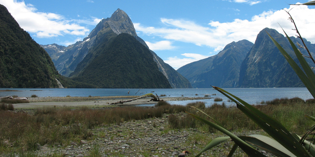
I travel by bus to Milford Sound and gaze in wonder at the grand scene of sheer rock walls plummeting into the black depths of the fiord. Mitre Peak's cleft summit rears up sharply from the black depths, mirrored to perfection in the glassy waters.
According to Maori legend, the great sea-god, Tu-te-Raki-Whanoa, carved Fiordland out of a solid mountain block with his great adze. Milford Sound has long been recognised as his greatest work.
The Waitaha and early Maori tribes followed the Greenstone and Hollyford Valleys to the West Coast in search of pounamu or greenstone.
Milford's first settler, Donald Sutherland, arrived with his faithful dog, John O'Groat, in 1877 and erected thatched huts by the freshwater basin he called the "City of Milford". He had set out from Dunedin in 1877 in an open sail boat, passing through Foveaux Strait and making the perilous passage up the Fiordland coast. Milford Sound was to become his home for the next 40 years.
He went on to construct a 12-room hotel to serve the growing influx of steamer passengers on sightseeing cruises.
Sutherland possessed a whimsical sense of humour and referred to his visitors as "asphalters" (city dwellers) and "shadow-catchers" (photographers). During the winters he lived a hermit-like existence.
With fellow adventurer, John McKay, he explored the Arthur River in 1880, having spotted a distant flash of water over the treetops. They came upon a waterfall and tossed a coin for the naming rights, which were won by McKay.
Later, they arrived at the base of a giant cascade, which became the Sutherland Falls - the third-highest in the world.
On a recent three-day tramp down the Hollyford Valley to Martins Bay, my guide recalled the exploits of Davey Gunn, who he earnestly described as "the greatest man who ever lived".
Often referred to as New Zealand's own Davey Crockett and the first real Southern Man, Gunn was as tight-lipped and laconic as any Speight's-drinking actor on today's flat screen.
In 1926, the legendary Gunn took over the Hollyford cattle run from the sons of Daniel McKenzie, the pioneer of Martins Bay. When the spread of red deer ruined his pastures he diversified into tourism, taking horse treks to remote wilderness camps.
One evening he heard a Fox Moth aircraft crash into the surf on Big Bay beach. Running into the sea he found one person dead and four injured. Realising they needed urgent medical attention he rode his horse, rowed a dinghy and ran on foot on an incredible mercy dash that covered 90 kilometres in 20 hours.
Fiordland has a panoply of pioneering heroes. The first European explorers, surveyors, run holders and traders all contributed to the beginnings of Te Anau.
Today, when I look at the modern Southern Man who receives an accolade from his cobber for producing a pack of Speight's beer on a muster, I think of the true pioneers that have gone before and feel humbled by their achievements.
It takes a visit to Te Anau and a wilderness tramp in the heart of Fiordland to understand the sacrifices they made and the hardships they endured.
Thanks to NZ Herald to run this article written by Paul Rush.